
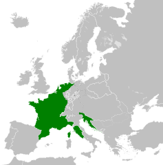
Dosiero:French Empire 1812.svg

Grando de tiu PNG antaŭprezento de tiu SVGa dosiero: 450 × 456 rastrumeroj. Aliaj distingivoj: 237 × 240 rastrumeroj | 474 × 480 rastrumeroj | 758 × 768 rastrumeroj | 1 011 × 1 024 rastrumeroj | 2 021 × 2 048 rastrumeroj.
Bildo en pli alta difino (SVG-dosiero, 450 × 456 rastrumeroj, grandeco de dosiero: 633 KB)
| Jen dosiero de la Wikimedia-Komunejo. La priskribo en ties priskriba paĝo estas montrata suben.
|
Resumo


.svg)
.svg)
.svg)
.svg)
.svg)


.svg)
.svg)
.svg)


.png)
.png)


.svg)


.svg)

.svg)


.svg)
.svg)
.svg)
.svg)


.svg)
.png)


.svg)


.svg)
.svg)


.svg)


.svg)


.svg)
.svg)
.svg)
.svg)
.svg)
.svg)
.svg)
_cropped.svg)
.svg)
.svg)
.svg)
.svg)
.svg)
.svg)
.svg)
.svg)
.svg)
.svg)
.svg)
.svg)
.svg)
.svg)
.svg)
.svg)
.svg)
.svg)
.svg)
.svg)
.svg)
.svg)
.svg)
.svg)
.svg)
.svg)
.svg)
.svg)
.svg)
.svg)
.svg)
.svg)
.svg)
.svg)
.svg)
.svg)
.svg)
.svg)
.svg)
.svg)
.svg)
.svg)
.svg)
.svg)
.svg)
Permesiloj:
Ĉi tiu dosiero estas disponebla laŭ la permesilo Krea Komunaĵo Atribuite-Samkondiĉe 3.0 Neadaptita.
- Vi rajtas:
- kunhavigi – kopii, distribui kaj publikigi la verkon
- aliigi – modifi, adapti, kompletigi, transformi, uzi la tutan verkon aŭ ties partojn, memstare aŭ en aliaj verkoj
- La verko rajtas esti kunhavigata nur:
- atribuite – Vi devas atribui aŭtorecon, liveri ligilon al la permesilo kaj marki ĉu ŝanĝoj estis faritaj. Faru tion en aprobinda maniero, tamen ne sugestante, ke permesinto aprobas vin aŭ vian uzon.
- samkondiĉe – Se vi rekombinas la verkon, transformas ĝin aŭ kreas devenaĵon bazitan sur ĝi, vi rajtas distribui la rezultan verkon nur laŭ la sama aŭ kongrua permesilo kompare kun ĉi tiu.
Dosierhistorio
Alklaku iun daton kaj horon por vidi kiel la dosiero tiam aspektis.
| Dato/Horo | Bildeto | Grandecoj | Uzanto | Komento | |
|---|---|---|---|---|---|
| nun | 00:02, 11 okt. 2015 | | 450 × 456 (633 KB) | Elevatorrailfan | Reverted to version as of 07:58, 14 July 2015 (UTC) No need to show states not part of the French Empire. |
| 16:53, 20 sep. 2015 |  | 450 × 456 (633 KB) | History of Persia | Why not? | |
| 07:58, 14 jul. 2015 |  | 450 × 456 (633 KB) | Elevatorrailfan | Un-highlighting Client states. | |
| 14:10, 28 jan. 2015 |  | 450 × 456 (633 KB) | DIREKTOR | User created page with UploadWizard |
Dosiera uzado
La jena paĝo ligas al ĉi tiu dosiero:
Suma uzado de la dosiero
La jenaj aliaj vikioj utiligas ĉi tiun dosieron:
- Uzado en an.wikipedia.org
- Uzado en es.wikipedia.org
- Uzado en he.wikipedia.org
- Uzado en hy.wikipedia.org
- Uzado en no.wikipedia.org